To view Part 1 (Quebec & The Atlantics), click here.
To view Part 3 (Western Canada), click here.
After seeing what the redrawing of Canada’s electoral map to include 30 new seats meant for Quebec and the Atlantics, we turn to the behemoth that is Ontario. They get their very own post because, as the Centre of the Universe, they’re simply greater human beings than the rest of us, and more deserving of media focus. Or maybe that’s just Toronto. The rage can be fairly arbitrary.
But Ontario gets its own post because 15 of the 30 new seats are here, and for good reason. Under the old map, the province had 15 of Canada’s biggest 25 biggest ridings, including the top six. By pundit law, I now must reference the schism between the 416 and 905 area codes. Where are these new seats? And who do they benefit?
Note: “Margins of victory” cites the difference in percent of vote between the first and second place parties.
SHORT ANSWER FOR PEOPLE WHO HATE READING
.
Where are the new seats?
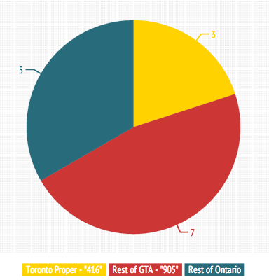
- Toronto: 3 seats
- Greater Toronto Area: 7 seats
- Rest of Ontario: 5 seats (Belleville/Trenton, Ottawa, Barrie, Kitchener, Hamilton)
Who do they benefit?
- Conservatives: 10 extra
- Liberals: 3 extra
- NDP: 2 extra
Alright, we can pack up and go now, right?
LONGER ANSWER FOR PEOPLE WHO LOVE POLITICS AND HATE THEMSELVES
.
Sigh and Grumble. Let’s go through our most populous of provinces in a way that makes some sense.
We’re going to sift through Toronto first, and we’re going to use specific terminology, so as not to confuse Old Toronto with the City of Toronto or the Toronto Metropolitan Area. Not to mention York and North York, which is actually south of York.
Just look at the map from Wikipedia.
So Toronto first, which has several districts that were once cities, before tackling the surrounding regional municipalities, which each have several cities that were once townships.
Confused yet? Here’s a Rob Ford gif.

Toronto (Old: 22. New: 25)
.
Where are the new seats?: Much of the GTA’s growth in the past decade happened in places other than Toronto, which is why the 905 gets seven extra seats and the 416 gets three. The three places where population booms have necessitated an extra seat?
- Increasing density around downtown Toronto means Trinity-Spadina and Toronto Centre lose their northern, less dense-halves (and Trinity-Spadina becomes Spadina-Fort York), creating the uber-wealthy University-Rosedale riding. In the 2011 election, it would have gone to the NDP over the Liberals by 13.2%.
- In North York, Willowdale, Don Valley West and Don Valley East all shrink to create Don Valley North (East), which would have gone Conservative by 3% over the Liberals, 40.3-27.3%.
- And in Scarborough, the city’s eastern edge no longer has to share a riding with Pickering and gets its own district, Scarborough-Rouge Park, which would have gone to the Liberals in a tight three-way race (Liberals 35%, Conservatives 32%, NDP 31%) in 2011. The city’s five other districts all shrink and shift a bit westward, while the old Scarborough-Rouge River becomes Scarborough North, which will confuse no one.
Geographical changes: Aside from the shifting required to accommodate the three new ridings, there’s very little disruption to Toronto boundaries. Six ridings stay exactly the same, York Centre loses a bit of space to Willowdale, Etobicoke Centre moves a bit to the south, St. Paul’s loses half of Davisville…but these are small potatoes.
Political changes: There are however big potatoes in areas where new seats were implemented, if “big potatoes” were an idiom.
First, the shrunken Toronto Centre would have only gone to the Liberals by 3.2% last election instead of 10.8%, as the riding loses the northern Rosedale polls the NDP were virtually invisible in last election. It’s one of the reasons the Liberals are seen as potentially stronger in University-Rosedale, even though it would have gone to the NDP by 13% in 2011.
David Akin makes this confusing calculus more palatable in a recent blog post.
In York (the ex-city, not the regional sprawl), the Don Valley North riding may have gone Conservative, but the changed boundaries of Don Valley East would have given it to the Liberals by 2%. Essentially, there’s now three Liberal-Conservative swing ridings in the region instead of four.

Finally, Scarborough-Rouge River loses Rouge and half of Malvern, so while it also changes its name to Scarborough North, it also becomes much less NDP friendly, becoming a seat they only would have won by 2% last election, as opposed to their comfortable 10.7% margin in 2011.
(Pundit Tip: It also would be a very competitive three-way race, which is par for the course in Scarborough. Under the new boundaries, five of the region’s six seats would’ve had the three parties within 10% of each other. If you want to make grand pundit pronouncements, talk up the Battleground That Is Scarborough.)
Durham (Old: 5. New: 5)
.
Geographical changes: The changes in Durham are intended so let every city have its own riding, instead of having a weird split with a neighbour. So Pickering-Scarborough East now has all of Pickering (and rural land stretching 60 km north), Ajax-Pickering is Ajax, Whitby-Oshawa is Whitby, and Oshawa…stays Oshawa, but reclaims its northwest neighbourhoods near the airport. And Durham is still the Big Rural Riding, but loses its western part to Pickering-Uxbridge.
Political changes: All five of these ridings went to the Conservatives last election, and all five of them would have still gone to them under this new map. However, Pickering-Uxbridge, formerly Pickering-Scarborough East, becomes much more Conservative with its new boundaries – going from a seat the Conservatives won by 2.5% to one they would have taken by 12.4%. Losing Scarborough and picking up 300 square kilometres of rural land will do that to a riding.
York (Old: 7. New: 10)
.
To view Part 1 (Quebec & The Atlantics), click here.
To view Part 3 (Western Canada), click here.
Where are the new seats?: When the riding of Oak Ridges-Markham was created before the 2004 election, the most recent census population was 111,276, from 2011. The 2011 census recorded a population of 228,997. Because the Conservatives won this riding by 22.9% in 2011, they’re the lucky recipients of a bunch of new seats. Three, to be precise.
So how do you turn one giant riding into four ridings?
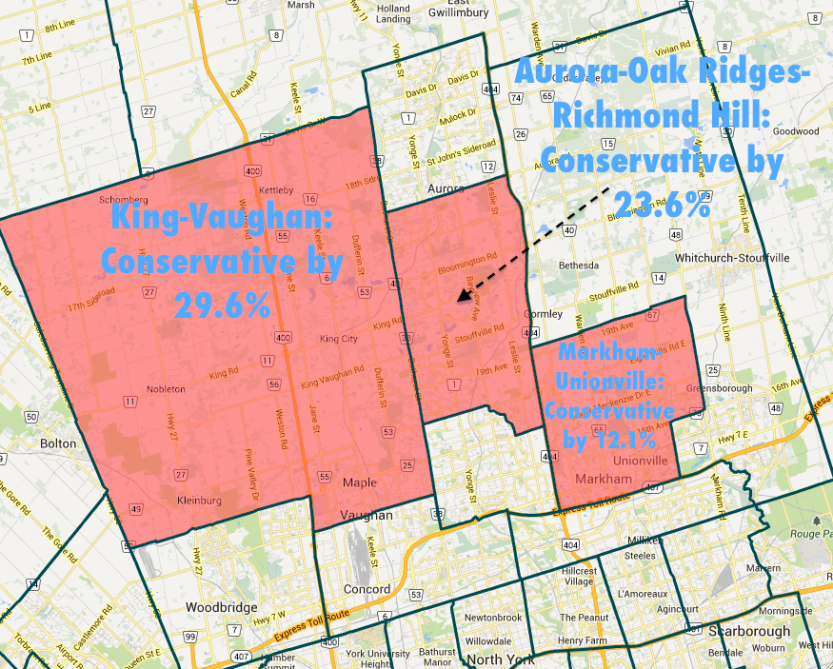
- The northern half of Vaughan and the vast expanse to its north it turn into King-Vaughan, which would have gone to the Conservatives by 29.6% last election.
- The suburban area west of the 404 between Richmond Hill and Aurora becomes the verbose Aurora-Oak Ridges-Richmond Hill, and would have gone to the Conservatives by 23.6% last election.
- Meanwhile, the northwest part of Markham gets its own riding of Markham-Unionville, which would have gone to the Conservatives by 12.1% last election. Meanwhile, the riding previously known as Markham-Unionville loses its area north of the 407 and becomes Markham-Thornhill, which will confuse nobody.
- Finally, Markham-Stoufville comprises the eastern, rural end of York and a little bit of Markham – and it too would have gone Conservative in 2011, by 12.1%.
Geographical changes: Oak Ridges-Markham was sprawling because it was parts of York that hadn’t become a large urban sprawl like Vaughan, Markham, Richmond Hill, Thornhill, and Newmarket.
So when Oak-Ridges Markham turned into the previous described four ridings, there was minimal changes for the other districts in the region. Vaughan lost its northern rural/suburban part, Markham-Thornhill changed its name and became smaller and Newmarket-Aurora ditched the Aurora and became self-contained in Newmarket. In addition, York-Simcoe lost the chunk of land to the west of Lake Simcoe, because the suburbs surrounding Barrie necessitated their own riding (we’ll get to that later).
Political changes:

Because of this, the political changes (outside those three new CPC-friendly seats) are minimal. (Pundit Tip: Perhaps the place worth paying most attention to is Markham-Thornhill, which would have only gone to the Liberals by .7% under the new boundaries, as opposed to the 3.4% they actually won it by when it was Markham-Unionville (THIS ISN’T CONFUSING AT ALL). But you can say things like “Markham-Thornhill is one of those 905 seats the Liberals HAVE to win if they want to form the government” and sound very wise.)
Peel (Old: 8. New: 11)
.
Where are the new seats?: Four of Ontario’s 10 largest seats came from the Brampton-Mississauga region known as Peel, which means some expansions are in order. Namely:
- Brampton West, which went to the Conservatives by 9.8% last election, splits in two, with Brampton South becoming a riding the CPC would have won by 5.9% over the Liberals, and Brampton West being one they would have won by 5.9%.
- Brampton Centre is created from the southern parts of Brampton-Springdale and Bramalea-Gore-Malton, and would have gone to the CPC by 21.2% last election.
- The centre of Mississauga, having achieved that crazy thing known as “density” (well, partial density), carves out its own riding of Mississauga Centre that would have gone Conservative by 5% last election.

Geographical changes: Mississauga South basically stays the same, while the four other Mississauga ridings shrink a bit to make way for the Mississauga Centre in the, um, centre of Mississauga. Brampton West and Brampton-Springdale each split in two, as discussed, while Bramalea-Gore-Malton, which experienced the 6th largest population growth from 2006-2011, gives up western and southern areas as it becomes Brampton East.
Political changes:

There are a few. First, Brampton East, a CPC riding by .9% in 2011, would have gone to the NDP by 6.9% with its new smaller boundaries. Mississauga East-Cooksville, which became plain old Mississauga Cooksville after some alterations, goes from a riding the Conservatives won by 1.5% to one they would have taken by 7.3%. And Mississauga-Brampton South, which went to Conservative by 9.6% in 2011, would have gone to them by just .6% under the new boundaries of Mississauga-Malton, which gains the area surrounding Pearson Airport and loses some of its western parts.
(Pundit Tip: The Conservatives won every seat in Peel last election, after winning just one in 2008. So if you want to sound profound, say something like “If the NDP or Liberals are going to make a real push, look for it to come in Mississauga and Brampton, where both parties went seatless in 2011.”)
Halton (Old: 3. New: 4)
.
Where is the new seat?: Oakville North-Burlington is split off from the suburban-rural riding of Halton (renamed Milton), and would have gone to the Conservatives by 27.2% last election had it existed. It may have been in the news lately. Perhaps.
Geographical changes: Literally the only change is the partition of Halton into two different ridings – which was badly needed because Halton had become the second largest riding in Canada (228,997 in the 2011 census).
Political changes: If people start talking about Soudas’ resignation, say with a knowing eye roll “It was a seat the Conservatives would be heavily favoured in regardless”.
Hey, we’re done with the GTA! That’s 10/15 of the new seats! Take a halftime victory dance.

Ottawa (Old: 7. New: 8)
.
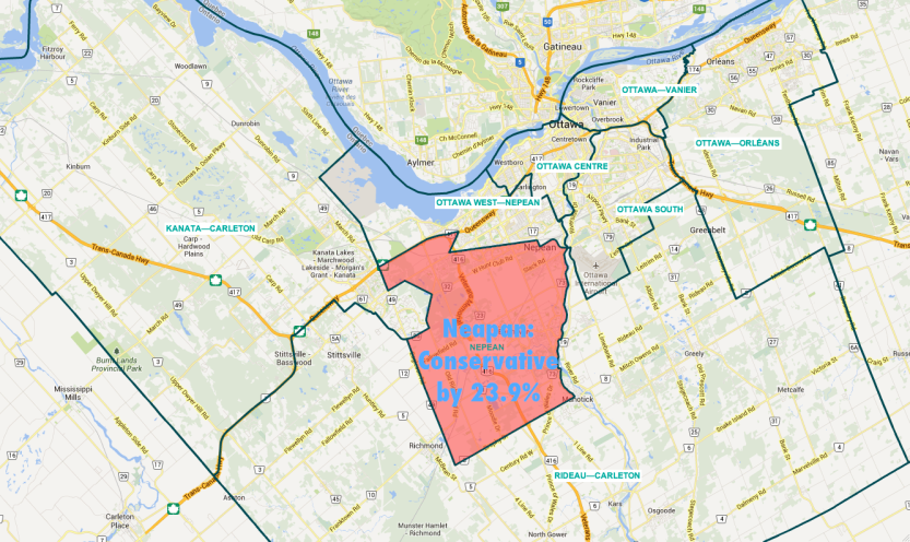
Where is the new seat?: Cut out from the heavily populated Nepean-Carleton (The Big Ottawa Suburb Riding to the South), the new seat of Nepean would have gone to the Conservatives by 23.9% last election.
Geographical changes: Nepean-Carleton, having lost Nepean, changes its name to Rideau-Carleton and takes the delightfully named towns of Stittsville and Richmond from Carleton-Mississipi Mills (now known as Kanata-Carleton, always known as The Big Ottawa Suburb Riding to the West). As the name change suggests, Kanata-Carleton loses Mississipi Hills.
Political changes: After losing Nepean, the Rideau-Carleton riding becomes much more conservative, going from a riding they won by 29.2% in 2011 to won they would have won by 40.8%. Pierre Poilievre fans will be enthused. Otherwise, no major changes.
Tech Triangle/Waterloo-Guelph Region/RIP Blackberry (Old: 6. New: 7)
.
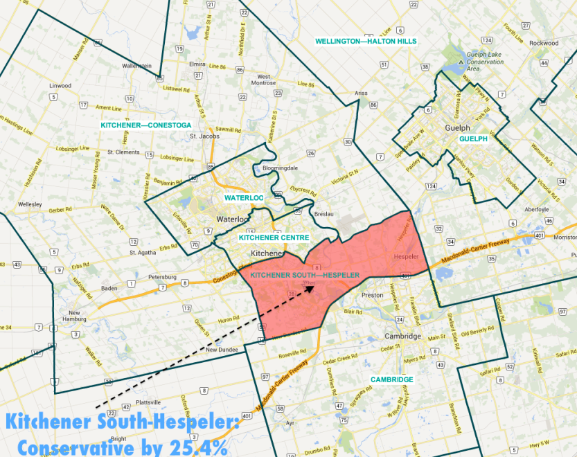
Where is the new seat?:The area between Kitchener and Cambridge has grown enough to get its own seat, Kitchener South-Hespeler, which would have gone Conservative by 25.4% last election.
Geographical changes: The boundaries of Kitchener Centre shift a bit to the east, Cambridge and Kitchener-Conestoga lose a big of room for the new riding, and Cambridge gains a bit of farmland to the south to adjust. But things stay mostly the same.
Kitchener Centre becomes a little less Conservative, but otherwise the changes are very minor.
(SIDENOTE: The rest of Southern Ontario can be divided any number of ways for political purposes. This is how we’re doing it here.)
(Cool? Cool. Let’s continue.)
Southeast Ontario (Old: 11. New: 12)
.
Where is the new seat?:The urban area of Hamilton gains a fourth seat in the perfectly named Hamilton West-Ancaster-Dundas. It would have gone to the Conservatives by 14.2% last election.
Geographical changes: The creation of a fourth Hamilton district results in small changes to Hamilton Mountain and Hamilton Centre. Ancaster-Dundas-Flamborough-Westdale expands east and becomes Flamborough-Glanbrook, becoming the sole riding for the townships surrounding Hamilton. Niagara West-Glanbrook shifts to the east, gains the township of Wainfleet, and becomes Niagara West. St. Catharines and Brant each lose a little of their farmland in their west, becoming a little more urban in the process.
Political changes: Niagara West becomes a little more Conservative, going from a riding the Conservatives won by 35.6% as Niagara West-Glanbrook to one they would have taken by 40.3% over the NDP. So does Flamborough-Glanbrook, which went to the Conservatives by 26.5% in 2011, but would have gone to them by 32.6% with the new, rural-only boundaries.
Southwest Ontario (Old: 10. New: 10)
.
Geographical changes: Essex loses a bit of its eastern edge to the Chatham-Kent riding. In the three London ridings, there are the following changes to the boundaries on the north side of the Thames:
Political changes: None of the winning parties would have had their margins changed by more than 2%. A non-affected area, Southwest Ontario be.
Western Ontario (Old: 7. New: 8)
Where is the new seat?: Everything’s looking up Barrie! The city’s continual growth (from 38,000 in 1981 to 136,000 in 2011) means it gets split into two urban-rural ridings. This should please the Conservatives – where as they won Barrie by 35.8% in 2011, they would have won the two new ridings of Barrie-Springwater-Oro-Medonate and Barrie-Innisfil by 34.5% and 41% respectively.
Geographical changes: Other than those changes to accommodate the new Barrie riding? Bupkis.
Political changes: Likewise. The seven Conservative-friendly seats that went to the CPC by 30-40% in 2011 will be eight Conservative-friendly seats in 2015.
Eastern Ontario (Old: 10. New: 11)
Where is the new seat?: The Trenton-Belleville-Prince Edward County area gets its own seat, named the Bay of Quinte. It would have gone to the Conservatives by 28.8% in the last election.
Geographical changes: Peterborough shifts to the north, while Northumberland and Prince Edward-Hastings (now Hastings-Lennox and Addington) gain some territory from neighbours to make up for Bay of Quinte taking some of their old areas. Kingston and the Islands loses its areas north of the 401 highway, becoming a bit more urban.
Political changes: Virtually nil. Kingston and the Islands, the only riding the Conservatives didn’t win here last election, becomes a little less friendly to them (going from a 4.4% margin for the Liberals to 5.9%), but that’s it.
Northern Ontario (Old: 10. New: 10)
Geographical changes: Reduced to 10 seats in 2004, Northern Ontario is officially at that awkward point where population dictates it should be reduced further, but political sensitivities dictate the areas representation not be reduced further. Which is how Kenora, despite having 40% less people than the average Ontario riding AND losing 13% of its population from between the last two censuses, remains a riding. As do the other nine ridings, with only minor changes.
Sault Ste. Marie loses the township of Laird to its south, and Algoma-Manitoluin-Kapuskasing gains swaths of land from Thunder Bay-Superior North and Nickel Belt. But otherwise, it’s pretty much status quo for the north.
Political changes: Yes!
Nipissing–Timiskaming went to the Conservatives by just 18 votes over the Liberals last election. But the rural areas of the town of Temiskaming Shores have been placed in Timmins-James Bay…and under the new boundaries, the Liberals would have taken the riding by 36 votes. So there’s that.

Summary: Ontario’s 15 new seats are broadly split in half between ridings the Conservatives will be heavily favoured in, and ridings that are three-way swing seats 18 months before the election. The 905 belt will remain crucial. And it only took 2650 words to reach that very simple conclusion!
Next time, we’ll tackle the west, which may be dominated by the Conservatives, but has the majority of the significant changes to the electoral map.
Categories: Rants


