To view Part 1 (Quebec & The Atlantics), click here.
To view Part 2 (Ontario), click here.
We could do an elaborate, writerly introduction to this section, but you want to learn about Western Canada’s 11 new ridings and a whole bunch of boundary changes, so let’s get to it. First, a quick reminder of very basic things.
Now, in Eastern Canada, 37 of the 213 old ridings stayed exactly the same, which helped move things along considerably. In Western Canada?
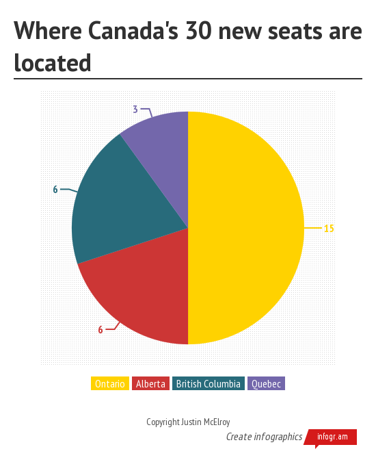
4 of 92. This will take time. The Coles Notes version of the changes (because “Spark Notes version” doesn’t have the same ring):
FOR PEOPLE WHO HATE READING
.
Where are the new seats?
- Metro Vancouver: 4 seats
- Metro Edmonton: 3 seats
- Metro Calgary: 2 seats
- Rural Alberta: 1 seat
- Fraser Valley: 1 seat
- Vancouver Island: 1 seat
Who benefits?
- Conservatives: 11 extra
- NDP: 2 extra
- Liberals: 1 LESS
Your eyes do not deceive. Already dominant in Western Canada, the 11 new seats give the Conservatives 11 new ridings they would have won in 2011, while weakening the Liberals. How could this be? Read on.
Note: “Margins of victory” cites the difference in percent of vote between the first and second place parties.
Manitoba (Old: 14. New: 14)
.
Geographical changes: The provincial commission was pretty big on keeping each riding within 5% of the average for the 14 seats, so there’s minor changes to most of the 14 ridings (8 in Winnipeg, 6 everywhere else), even though Manitoba never changes the population distribution of different regions has remained relatively static.
First, the non-Winnipegs. Churchill gains the northern half of the Interlake Region, and gains a suffix, becoming Churchill-Keewatinook Aski. Dauphin-Swan River-Marquette changes its last suffix to “Neepawa”, and extends its southern border to just north of Brandon, gaining the town of Carberry. Brandon-Souris takes a bit of farmland from Portage-Lisgar, which takes some farmland from Provencher, as does Selkirk-Interlake, which adds “Eastman” to its suffix.
Fine. We’ll explain the most pedantic changes with a map.

In the big city, Winnipeg South Centre takes Linden Woods from Winnipeg South, while Winnipeg North and Elmwood-Transcona each take a few blocks on the city’s northeast and northwest edges from Kildonan-St. Paul, the medium-sized suburb-rural riding immediately north of Winnipeg proper.
Again, minor changes. Same as it ever was. For comparison, here’s a side-by-side of the new electoral map, and Manitoba’s map from 1895.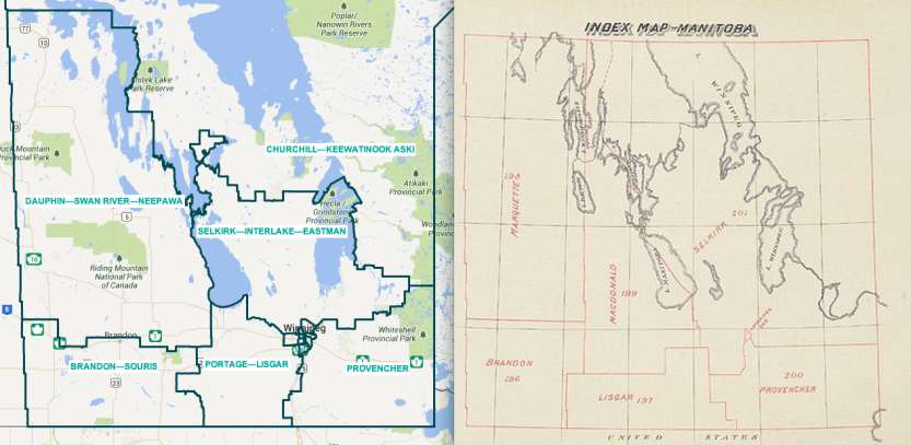
Political changes: The Liberals won Winnipeg North by 44 votes over the NDP in 2011, but they did very poorly in neighbouring Kildonan-St. Paul, with just 8.2%. Adding those few blocks to Winnipeg North gives the NDP a couple hundred more votes, swinging the riding in their favour. In addition, the addition of Linden Woods to Winnipeg South Centre helps the Conservatives—they took the riding by 1.8% over the Liberals in 2011, but would have taken it by 4.6% with the new boundaries.
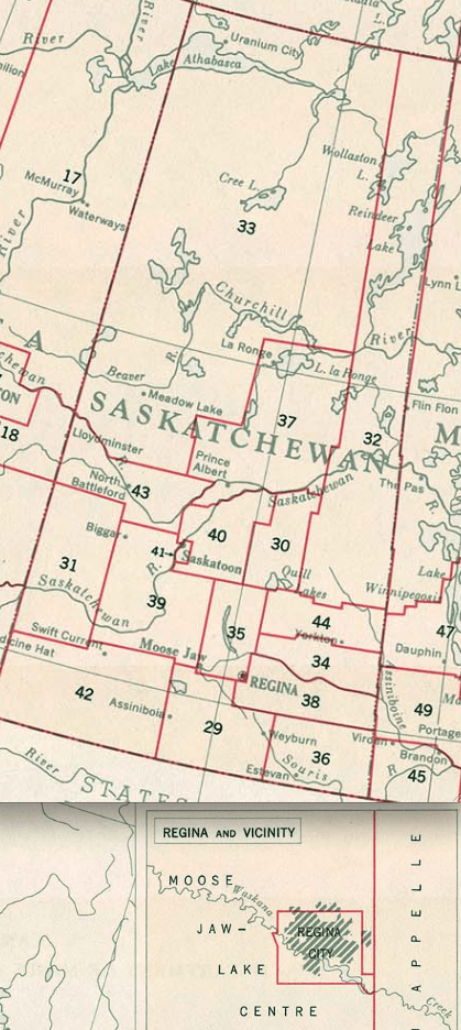
Saskatchewan (Old: 14. New: 14)
.
Geographical changes: Oh, boy howdy.
Historical story time. In the 1930 election, Saskatchewan was the third most important province in the country. No really, it was! Didn’t you pay attention when your History 10 teacher was going on about Clifford Sifton?
In the 1931 census, Saskatchewan had a population of 921,785. Since then, it’s only grown by about 10%. Canada’s population has grown by about 330%. So things were going to change.
But in those heady days, Saskatchewan had 21 of Canada’s 245 seats—one for Regina (population 53,209), one for Saskatoon (43,291), and 19 divided up by townships that often spanned a number of small cities.
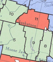
By 1965, there were still 17 seats for Saskatchewan—one for Regina, one for Saskatoon, and 15 for the rest.
After that election, Saskatchewan was forced to cut four seats. The solution? Because we* all know that proposing large increases to the size of rural-only seats is a non-starter, the urban-only seats of Saskatoon and Regina (now both around 100,000 people) were turned into urban-rural seats, split between two ridings each.
This allowed the majority of Saskatchewan ridings to keep the status quo. And that status quo would last forever and ever…
…Until 1988. By this point, the two main cities were getting close to 200,000, while the rest of the province had lost around the same number of people as the big cities had gained. The solution was to keep on partitioning Saskatoon and Regina. Why have two urban-rural ridings per city when you can have three?
…Did I say three? Because that lasted just two elections, before population levels had to be evened out again before the 1997 election, and thus was born Saskatoon and Regina’s four urban-rural ridings. Each. Over half of the province’s ridings were urban-rural hybrids for the last six elections, while none were completely urban.

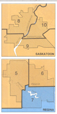
This time around, while one of the three members of the election commission argued for the status quo, the other two thought that people in downtown Saskatoon shouldn’t have the same MP as people in Rosthern or Osler or Hague.
Now there’s two urban-only ridings in each city and one urban-rural split. Like so:

This infuriated the Conservatives, who initiated robocalls to try and get people to speak out on the changes. Who claimed there was “overwhelming opposition” to the changes. Who have either won 12 or 13 of the province’s 14 seats in each of the last four elections with less than 60% of the vote.
Whoops, that last one implied there were political machinations at work. We all know political machinations never enter into Canadian politics.
So there’s your history and context to this most controversial of boundary changes. What does it actually mean?
Well, most of rural parts of Saskatoon-Wanuskewin, Saskatoon-Rosetown-Biggar, and Saskatoon-Humboldt essentially merge into one large overly wordy rural riding known as Humboldt-Warman-Martensville-Rosetown. Similarly, most of the rural parts of Blackstrap, Regina-Lumsden-Lake Centre and Palliser merge into Moose Jaw-Lake Centre-Lanigan (soon to become known as “The Moose Jaw Riding Between Regina and Saskatoon). There’s a few other farmland exchanges between ridings, but they’re relatively small.
Political changes: The six ridings that never contained Saskatoon or Regina? They stay mostly the same. Desnethé–Missinippi–Churchill River (The Big One in the North) went to the CPC by 3.6% in 2011, but would have been just 1.5% with the new boundaries. The Conservatives won the others by 30-plus per cent.
Those two new all-rural ridings? Humboldt-Warman-Martensville-Rosetown would have gone to the CPC by 43.9%, and Moose Jaw-Lake Centre-Lanigan by 29.5% – numbers larger than any of their wins in the eight urban-rural hybrid ridings of yore.
What about the two hybird ridings that mostly maintain their previous boundaries? Regina-Qu’Appelle goes from a riding the Conservatives won by 15.1% to one they would have taken by 14.6%. More significantly, Saskatoon-Grasswood goes from a riding the CPC won 17.6% to won they would have won by 10.4% under the new, significantly smaller boundaries.
And the four urban-only ridings? Saskatoon-EastUniversity would have gone to the Conservatives by 10.6% last election, while Saskatoon West would have gone to the NDP by 8.6%.
Regina-WestLewan would have gone to the NDP by 1.3%, 45.2-43.9 over the Conservatives. Finally, Wascana (home of Liberal Ralph Goodale and only riding in Saskatchewan the Liberals got more than 10% in) goes from a riding he won by 3.9% to one he would have taken by 6.1%.
In summary, of the previous 8 rural-urban ridings, 2 become rural-only (heavily favouring Conservatives), 2 shrink a bit but still keep a split (which mostly favours the Conservatives), while 4 become urban only (profiling for the moment as Conservative-NDP swing seats).
Alberta (Old: 28. New: 34)
.
Where are the new seats?:
- The place that always votes for the Conservative party gains another seat. It will vote for the Conservatives again.
- So do the other five places.
I go for the low-hanging fruit. But we’ll take a bit of time on this because while it *may* not seem to matter for electoral prospects, there were some serious changes to Alberta’s map. We’ll divide this up into the three regions People Outside Alberta believe the province to comprise, and my apologies to the offended People Inside Alberta.
Calgary (Old: 8. New: 10)
.
The “problem” with drawing new maps for such a fast-growing city is that different areas grow faster than others, and so adding two additional seats can’t be a uniform experience. But Calgary Southeast and Calgary-Nose Hill were a) the two seats in Calgary with the largest population, and b) the two seats with the largest growth since 2006, so it’s out of those general areas where the city gets its extra seats.
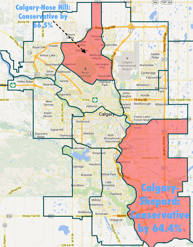
- In the southeast, Calgary Shepard becomes a mishmash riding of pretty much everything east of the Bow River and south of 26 Avenue SE. There’s a giant industrial area in the middle, and it would have gone to the Conservatives by 64.4% last election.
- In the northwest, you could make a case for either Calgary Nose Hill (would have gone CPC by 66.5%) or Calgary Rocky Road (would have gone CPC by 55.8%) being the new riding. I’ll go with Nose Hill on the fancy map though.
Geographical changes: Virtually all the changes make the Bow River a dividing line, which is helpful. Calgary North-Centre loses its tony neighbourhoods to the north, gains the area to the west surrounding the University of Calgary, and becomes Calgary Confederation. Calgary Southeast loses its areas east of the Bow and becomes Calgary Mindapore. Calgary Centre shifts to the east so it borders the Bow on two sides. Calgary West becomes Calgary Signal Hill and loses its area north of the Bow. And Calgary East dramatically transforms into Calgary Forest Lawn, centred around the areas around the Trans-Canada east of Bow.
Political changes:
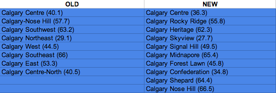
There are a few changes, but you can fill in the Conservative-domination punchline here. The changes to Calgary Confederation bend it to the Liberals by 6%, and as Dan Arnold notes, it could become a competitive riding in time.
Edmonton Area (Old: 8. New: 11)
.
Geographical changes: The Edmonton Area basically comprises the city itself, along with the smaller towns of Spruce Grove (West), St. Albert (Northwest), Fort Saskatchewan (Northeast), Sherwood Park (East), and Leduc (South). Nearly every redistribution sees the philosophy change when it comes to dealing with these towns – although the slightly larger and slightly closer St. Albert has been a mostly self-contained seat for a while.
Outside of St. Albert, those surrounding regions keep the three seats they have currently, but they lose their Edmonton areas, and now have as much in common with rural Alberta than with urban Edmonton.
As for Edmonton proper? The three areas that used to share an MP with one of the towns each get their own seat – Edmonton West (would have gone CPC by 44.7%), Edmonton Riverbend (would have gone CPC by 38.2%), and Edmonton Manning (would have gone CPC by 28.9%).

Political changes:
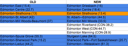
Unsurprisingly, those three pseudo-Edmonton ridings become more Conservative when gaining large swaths of rural land. Edmonton Griesbach (née “East”) and Centre become a little less favourable to the Conservatives with their smaller boundaries – the NDP and Liberals had more votes than the Conservatives within the newly configured Edmonton Centre. Finally, the only non-Conservative seat in Alberta, Edmonton-Strathcona, stays pretty much the same.
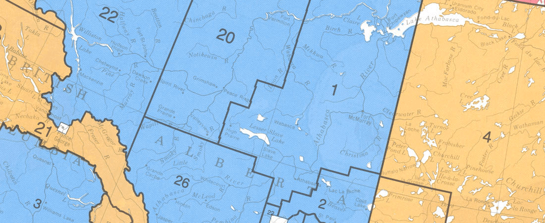
Rural Alberta (Old: 12. New: 13)
.
Geographical changes: Everywhere changed, and it’s a confusing mash. Seriously, look at the overlay of new and old boundaries.

Here’s what you chiefly need to know though, should you be sucked into one of those all-too-common Rural Alberta Redistribution Debates: Lethbridge becomes much smaller, having only a couple of towns less than 50km away as part of its catchment. Red Deer, which used to be one mostly-urban riding, is now split between two urban-rural split ridings, Red Deer-Wolf Creek and Red Deer-Mountain View. Those changes scrunch and shift around the other rural ridings in southern Alberta, to the point where Vegreville-Wainwright basically ceases to exist.
And finally, population increases in northern Alberta (which happened for OIL! OIL! OIL! unknown and definitely non-controversial reasons) give that area a third seat. Peace River-Westlock comprises much of the central area of the region between Fort McMurray and Grand Prairie, and it would have gone to the Conservatives by 64.8% last election.
Political changes: With the exception of Lethbridge (which had unique circumstances), every seat went to the CPC by over 50% last election. It would be the same next time. The dominant right-wing party has won every rural Alberta seat, in every election, since 1968. For brevity, we’re moving on.
British Columbia (Old: 36. New: 42)
.
Where are the new seats?: B.C. is a tricky riding to profile politically because there are so many regions with distinct political cultures, whether it’s due to geography, local economy, or migration trends. Which makes redistribution a teensy-bit fraught. Four of the six new ridings are based in Metro Vancouver, one is in the Fraser Valley, while the other one is on Vancouver Island. They are as follows.
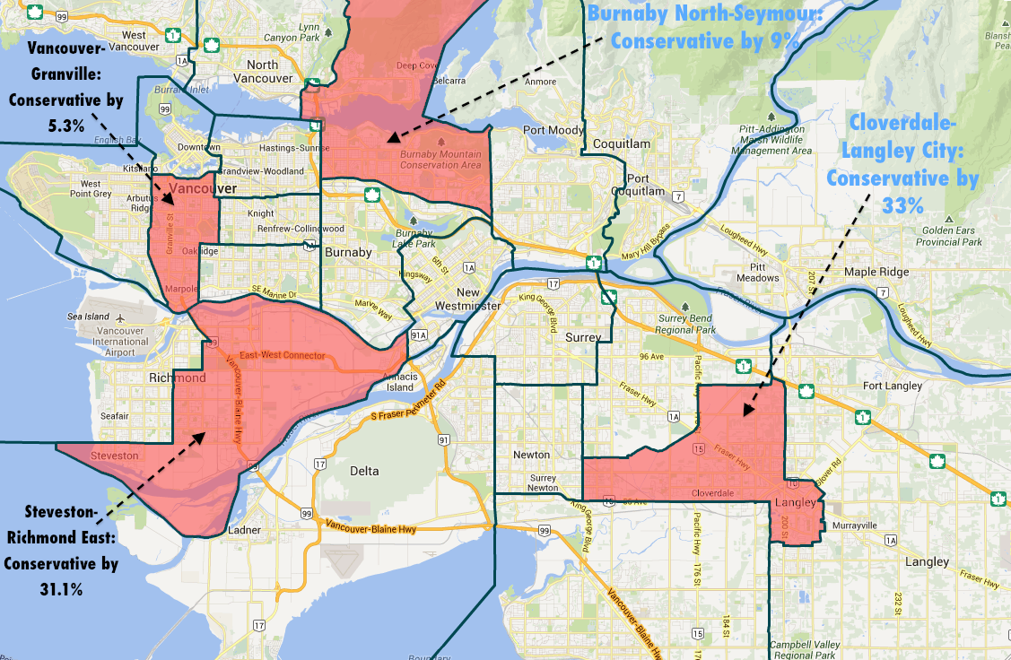
- Vancouver Granville is split down the centre of Vancouver, taking a little bit of land from all five Vancouver ridings. It would have gone to the Conservatives by 5.3% of the Liberals last election.
- The large riding of Delta-Richmond East was split in two, and since incumbent Conservative MP Kerry-Lynne Findlay says she’ll run in the Delta riding, we’ll call Steveston-Richmond East the new riding. It would have gone to the Conservatives by 31.1% last election.
- Much maligned by NDP politicians, North Burnaby-Seymour takes the eastern half of right-leaning North Vancouver, the northern half of left-leaning Burnaby, and smushes them together. Spoiler—the North Vancouver area is larger, and the Conservatives would have taken this new seat by 9% last election.
- Cloverdale-Langley City is a predominantly urban riding surrounded by farmland in Langley and Surrey. It’s the fastest growing area of Metro Vancouver, and would have gone to the Conservatives by 33% last election.
- Maybe the most hodgepodge riding in BC, Mission-Matsqui-Fraser Canyon encompasses the farmlands of north Abbotsford, the small Fraser Valley towns north of the Fraser River, and interior towns like Ashcroft and Lillooet nearly 300 kilometres away. It would have gone to the Conservatives by 22.5% last election.

- Finally, the cities between Victoria and Nanaimo on Vancouver Island have grown enough for another riding to be created between them. Cowichan-Malahat-Langford would have gone to the NDP by .5% over the Conservatives last election.
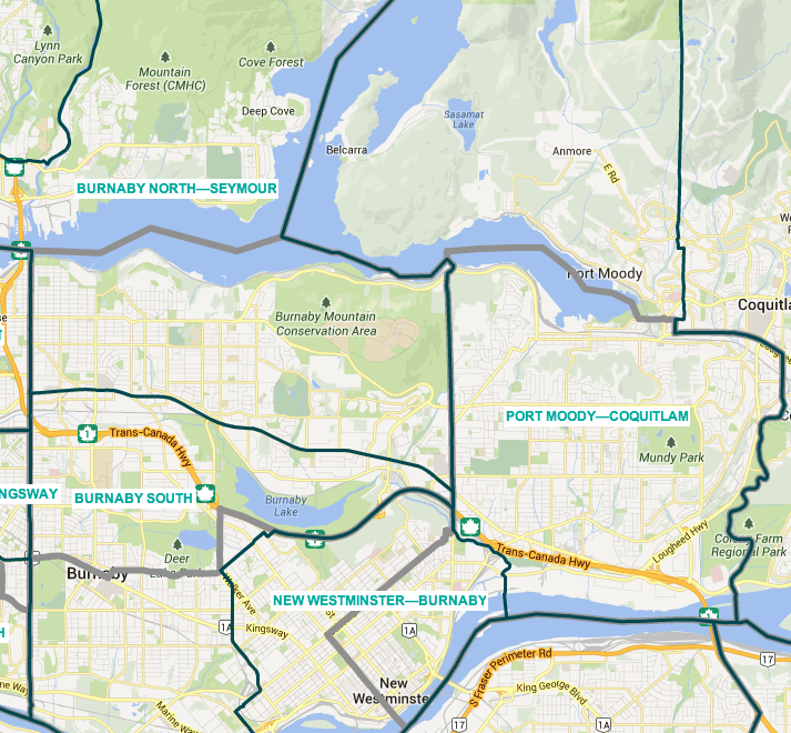
- Geographical changes: There are small changes everywhere. Very briefly, the “North Delta” part of Newton-North Delta goes to Delta. A third seat is created for the middle of Vancouver Island between Victoria and Comox Valley, squishing the previous two. The changes to the Burnaby/New West/Tri-cities area level out population levels, but are full of small changes.

Burnaby-Douglas shifts south and becomes Burnaby South, Burnaby-New Westminster shifts east and becomes New Westminster-Burnaby, and New Westminster-Coquitlam shifts northeast and becomes Port Moody-Coquitlam. ALL VERY SIMPLE. Vancouver Island North also has some funky changes: While they add Powell River from the upper Sunshine Coast (becoming Vancouver Island North-Comox-Powell River), they lose NDP-leaning Courtenay but not Conservative-leaning Comox on its southern border. It looks very fishy at first glance—but the two cities are separate municipalities (which counted for a lot with all commissions), and the addition of the NDP-leaning Sunshine Coast evens things out politically.

These are two separate cities. I promise. Finally, in the southern interior, there are a whole bunch of changes, which we will summarize with, mercifully, the final map of this redistricting odyssey.
Political changes: The changes to the Burnaby/New West area of Metro Van not only add a new seat that would have gone Conservative last election – it also flips one of the ridings from the NDP to the Conservatives. NDP MP Fin Donnelly, who won New Westminster—Coquitlam by 4.5% last election, will now be running in Port Moody-Coquitlam, which would have gone Conservative last election by 6%.
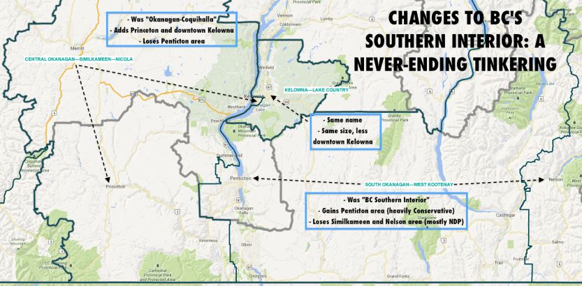
In the Interior, the changes mean South Okanagan-West Kootenay would have gone to the Conservatives by 5.4% last election, while Kootenay-Columbia, which went Conservative by 22.7% last election, would only go to them by 12.3% with the new boundaries.
And finally on Vancouver Island, the rejigging means the two ridings in the middle of the island that produced a relatively stable NDP-Conservative split over the last three elections are now three swing seats, at least based on 2011 numbers.

And we’re done! Go outside. Hug your children. Volunteer somewhere. We’re over a year from an election. You spent too long reading this. I’m not going to think about where that leaves me.
*OK, I knew this, because I looked at 20+ redistributions in Canada and BC over 100+ years, for some reason. It’s fair if you didn’t.


Categories: Rants
